Friday, February 28, 2014

Itsy Bitsy II

While hopping over the fence that's our shortcut from the driveway to the back door, I noticed this fella cruising around. What really caught my attention were the green fangs.


Natural habitat

After hurriedly constructing an impromptu photo studio inside suitable for a small visitor, I convinced Murphy to wrangle him (her?) inside safely for a short session. Took him a minute to become cooperative, but after he gathered that he wasn't in any immediate danger, he was pretty chill.


Posed

After I was satisfied, I returned him to the spot I found him, and I think he was happy to be home. Probably saw spots for a few minutes, but that's the price of doing business :)

I sure hope he wasn't poisonous. Didn't really look it, and we didn't find out the hard way.

The last Itsy Bitsy post was 2.5 years ago. Probably won't be a frequent series...

-

Wednesday, February 26, 2014

Seattle, Quickly

A couple weeks ago, I found myself in Seattle for about 24 hours for a work trip, and Murphy tagged along to be somewhere different for a day and catch up with a few friends. Trips like this are exhausting but super fun; it's always a good reason to find some good food and some interesting sights, but I feel like there's never time to delve too deeply into anything.

What with a four hour meeting and some mandatory (OK, not mandatory, but wise) sleep, our exploration was largely limited to the journeys between various purveyors of food, beverage, and transportation. There are worse ways to go through life.


Yay geometry and patterns!

If I recall correctly, our wandering path was something along the lines of Sea-Tac, Light Rail, lunch (Merchant's), beer (Ivar's), dinner (Le Pichet OMG yes yes yes), and the Bainbridge Ferry. That was about all we accomplished on the first day, but traipsing from food to drink to food feels decadent and should be experienced at least once every election cycle.


Regan sees the future


The Great Wheel (made without tripod, thankyouverymuch)

There are MUCH better photos of the Great Wheel with all sorts of interesting compositions to be had, but I a) had no tripod, and b) was chasing a hungry group of compatriots, so I took the low-hanging fruit. Actually, not really. To make this photo, I reached over a fence separating the pier from the harbor, balanced the edge of my camera on a thin strip of concrete, and propped it there with a finger for the length of the exposure, a sneeze away from watching more money than I'd care to admit plunge to its salty death far below. In other news, this is now my definition of living dangerously.


Harbor Steps

I had never been out to Bainbridge before, and I must say I was super impressed with the ferry, probably because we didn't ride it at rush hour. Less than eight bucks for a round trip, very frequent, and remarkably easy. Party on.


Abstract Ferry selfie

On the second day, our accomplishments were even more sparse. After my meeting (Ethel went to the city early), it was Bainbridge Ferry, lunch (Etta's), coffee (Moore Coffee Shop), and then back to Sea-Tac.

On one hand, I despise visiting places without the time to really explore, but on the other hand, it's fun to dip into a city's plane of existence for a few hours and then get whisked away from the fray.

-

Thursday, February 20, 2014

Anchor Bay Part III: Holey Yoga

One of our other little diversions on the unnamed beach near Anchor Bay was to exploit Murphy as a model for some impromptu photos. Above one section of the beach was an AMAZING sandstone wall, and I figured it would serve as a good backdrop for something or other.

Thus, I enlisted Riley as light-slave, convinced Murphy to contort herself for the sake of art, and the rest just kind of happened.


Cozy nook


Not so good, grasshopper


Enlightened

Ethel's gotten way better over the years at pretending like she enjoys this rampant exploitation.

That's it from Anchor Bay; thanks for playing!

-

Tuesday, February 18, 2014

Anchor Bay Part II: The Beach

The seven regular readers will recall that Murphy and I visited Anchor Bay along the CA coast, but if you're joining us midstream, well, there you go. We had a great time with the combined Theilen-Maclean-Vagabond troupe, but our stay was cut short by rapidly closing bad weather along our route home.

The unnamed beach I mentioned in the last post was not interested in providing us with good weather, so to call it a beach doesn't really connote the right feeling. Maybe instead we'll call it a sandy stretch on which to observe the ocean and to be battered by wind, waves, and occasional sprinkles.

In any case, the ocean is a fun place to make photos, provided that you're willing to pluck your tripod, with catlike reflexes, away from the occasional rogue wave. Or to be continually scraping sticky ocean sand off various surfaces of your camera.


Driftwood

These two photos struck me as both interesting and also representative of the feeling the weather imparted to the beach.


Standing tall

One more to go from this trip, and then you can get back to your lives. Thanks for dropping by.

-

Monday, February 17, 2014

Anchor Bay Part I: Wandering

Last fall, Murphy and I made a quick 6ish-hour blast to the coast to visit Matt and TJaye's getaway in Anchor Bay, also coinciding with a visit from the Vagabonds, Riley and Erin. Anchor Bay is one of those can't-get-there-from-here types of places, at least if you're coming from Reno. Brave the Bay Area's traffic and be rewarded with a more direct route, or go way north, avoid the throngs, and toss thyselves about on some twisties. We chose the latter.

Matt and TJaye have use of a family cabin on the uphill side of Highway 1 ("The 1," if you're from California, or "from" California...), and it features flat places for 5 people to sleep, running water, and electricity. In other words, it's totally livable, somewhat decreasing its Cabin Score, but it makes more sense to use it as a jumping-off point for further fun/relaxation/hijinks/etc.

Our first obvious stop is right down the hill to the neighborhood beach. It's a steep descent (and climb back out), but some form of suffering should be required to receive fun in return, right?


5-minute walk down the hill to here...


...plus navigating the sketchiest staircase this side of the Mississippi


Fertile rock face

I'm itching to get out for a run, so that's my next mission. I continue up the super steep road their abode is on, past quite a few shacks, but more noticeably, past a preponderance of No Trespassing, Keep Out, and Private Property signs. You see, this is Mendocino County, weed stronghold extraordinaire, and these growers take their property lines seriously. Never mind the overwhelming wafting aroma of fresh bud. For once, I'm glad to be running on the paved roads; I'm a little nervous about what would happen if I rounded a corner too quickly out in the woods... Anyhow, I get to watch the sun set from way up high above the ocean, and then I descend the steep roads quickly to make it back in time for dinner.

The evening is spent eating, drinking wine, and laughing.


His Highness stirs

Riley and Erin have slept in the van, and Murphy and I have taken advantage of a flat spot on which to chuck a tent. Thus, we're all up fairly early, although all that really counts is that I am up before Riley with enough time to grab my camera.

More awesome food happens, and then we make a mission to an unnamed beach to the north that's totally easy to find: drive along the twisty section of Hwy 1, then make a frantic U-turn on this side of a blind rise, pull off the road, and walk through an opening in the trees to find the trail.


Fast friends

We spend a couple hours on this blustery beach. You could call it wasting time, but I seem to recall everyone being pretty well occupied with something or other, so I guess it's not really a waste.

Unfortunately, once we're back to cellular reception, we discover that the weather forecast over the pass has deteriorated rapidly, and we're looking at either leaving immediately, or staying our planned next night and probably one or two after it, also. It burns badly to do so, but we opt for the pronto approach and blast away from the ocean. Always a bummer to miss out on time with friends, but we weren't equipped with 4WD or chains, and missing 2ish days of work wasn't good for either of us, so we did what we had to do.

I've got a couple more sets of photos to share from Anchor Bay that are slightly less scattered than these, so stay tuned for the rest.

-

Thursday, February 13, 2014

Assault on Eisen

Some number of months ago at work, we landed on a naming scheme for internal projects that centered around Sierra peaks. One of these projects was named Eisen, and I decided that naming a project after a peak would necessitate visiting said peak for a looksee.

Next time, I'll spend more time researching namesake peaks before assigning them to projects.

Eisen is a lovely 12k' peak down in Sequoia National Park, which is a mind-numbing 8-hour drive from Reno. Actually, scratch that. It's a mind-numbing 6.5-hour drive followed by 90 minutes on a barely-paved and largely unmaintained road that was installed before civil engineering had been invented. They say to allow 90' for the 25-mile road, and I was driving hard, and it still takes 90 minutes. Murphy gets sick.

Anyhow, we pull into the trailhead parking lot after midnight and crash in the back of the car for a whopping four hours. Our plan is to summit Eisen and return in the same day, and it is both A Long Way and Partially Overland. In other words, welcome to the bonus round.

Like all good days, this one begins with headlamps, and I'm expecting that it will end with them, too. There's lots of ground to cover and a solid 15 hours before the headlamps would make another appearance anyway, but I'm willing to accept whatever the day throws our way.


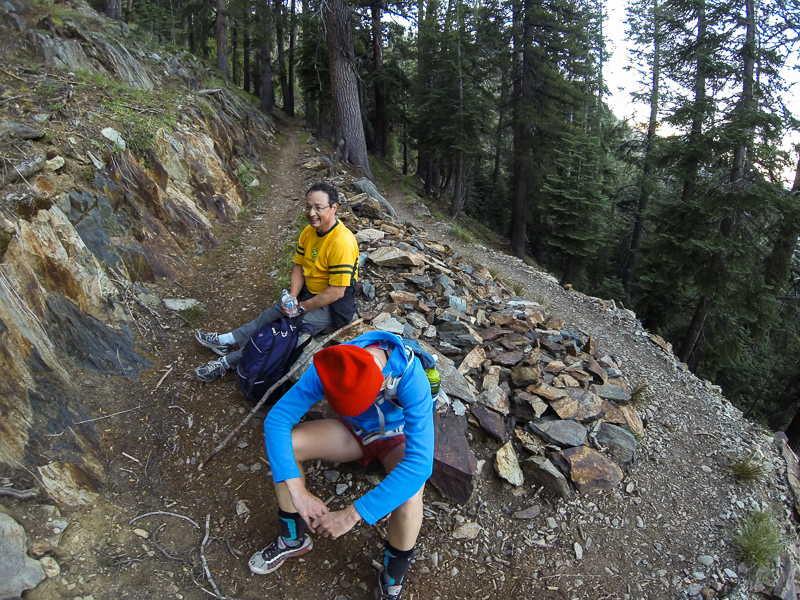
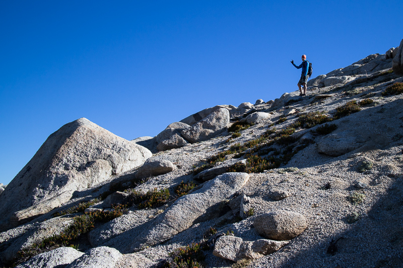
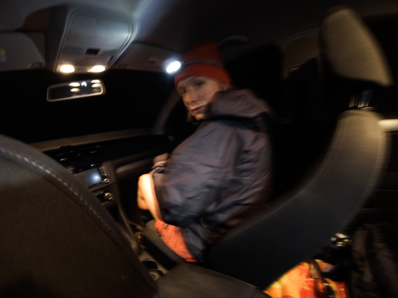
Murphy looks as fuzzy as I feel after four hours asleep in the back of the Golf

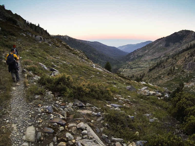
So we get a ~4:45am start along with Peter, a guy with whom I work who has traveled from the Bay (shorter trip, so he got to sleep), and start the first big climb. It becomes apparent to me in the first few minutes up the trail that we'd be lucky to summit; the correct crew for a mission like this is probably a deranged solo ultra runner, as which none of we three qualify. However, I suspend that thought and realize that a day in the woods is always better than a stick in the eye. Onwards!


Climbing above the receding veil to the west


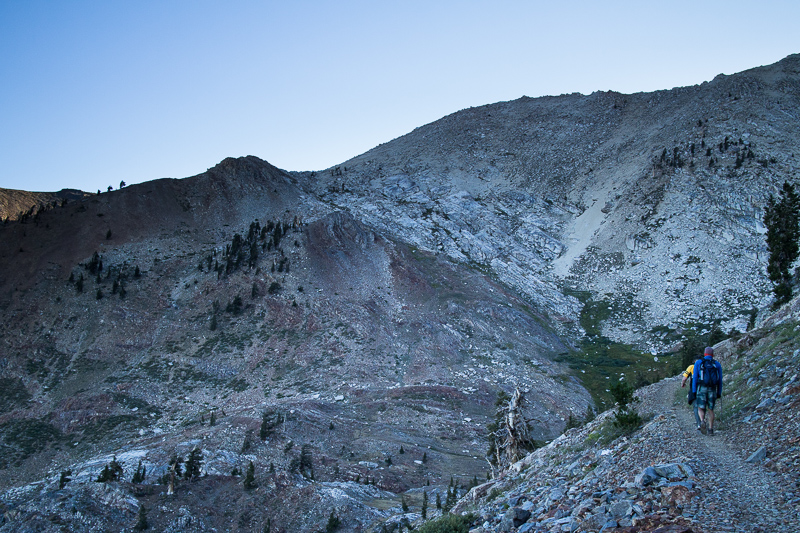
It isn't -that- bad of a climb; only 3500 feet or so

Up and up we go, climbing into the basin that drains the Monarch Lakes and is guarded by Mineral Peak. We then climb a steep and loose DG slope to the ridgeline below Sawtooth Peak and get our first view over to Eisen.


Headed up toward Monarch Lakes


Lower Monarch Lake and Mineral Peak

Our gear strategy is light and fast; we've got practically nothing with us, and that helps us to both move quickly and also avoid too much stopped time. We've got water (and a filter), snacks, a GoPro, and another tiny camera, and that's about it.
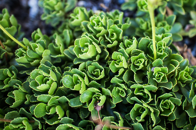

Life above treeline


I can finally see past the horizon


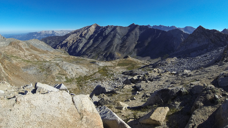
Eisen (left-center), with lots of ground between here and there, and the Kaweahs beyond

From here, the maintained trail goes the wrong way, and we look for the old unmaintained trail that will get us to the overland section and ultimately save us many miles of hiking. Unfortunately, this unmaintained trial proves hard to find (I know where it is now...), and we lose nearly an hour navigating a "trail" above a cliff face that I would have avoided had I seen it from below first. Calling it "exposed" doesn't really do it justice.

This miscue, combined with seeing the rest of the route, pretty much cements that we won't be summiting. The overland section is about as easy as it gets, but then there's a 2000' set of steep (and loose) switchbacks to Black Rock Pass, followed by the crux, which is about a mile of VERY exposed ridgeline to the northwest.

Ultimately, we decide to keep the group together, take in the view of Eisen from afar, and spend some time enjoying the outdoors instead of just hammering along the trail (or lack thereof). We descend the finally-found unmaintained trail down toward Spring Lake, where we lunch and enjoy the grandeur of our personal amphitheater of Sierra peaks.
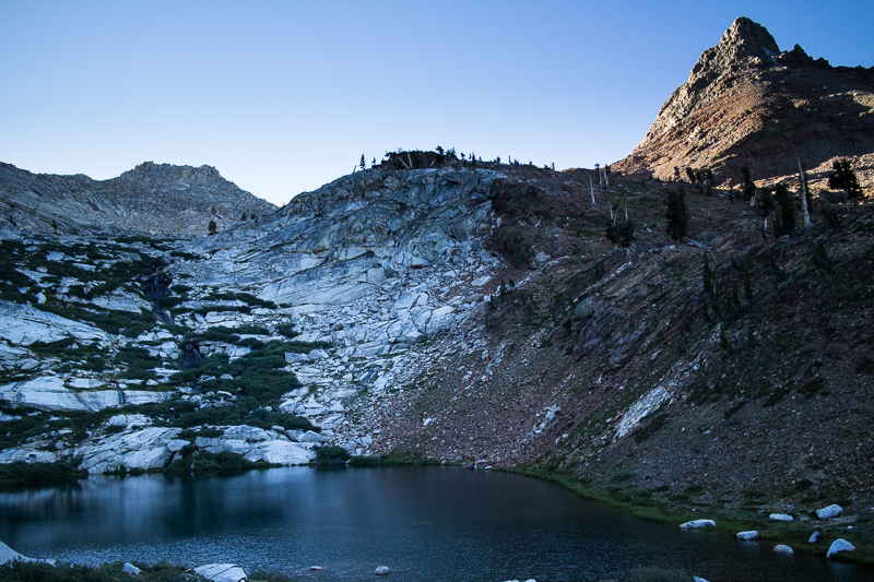
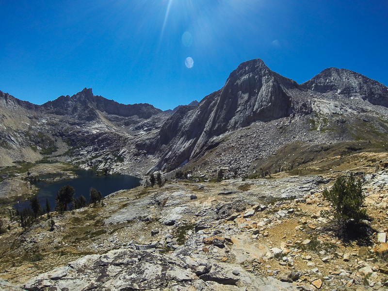

Spring Lake below

After eating, basking in the sun, and generally being stoked on being outside, we gather our sparse belongings and turn our back on Eisen.


Our basin


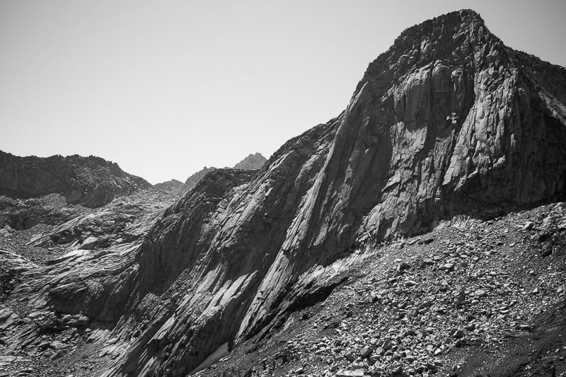
And the peak that guards it

We pop back over the ridgeline into the Monarch Lakes area and hurry along the big descent back to the cars, parked just below 8000'. By the time we make it back, we've still been on the trail for a solid 10 hours, and we've got 8 hours of driving ahead of us. I know that it's certainly possible to flash Mount Eisen, but it'll take some more sleep ahead of time, the knowledge we gained on this recon mission, and some staunch determination to haul ass all day long.

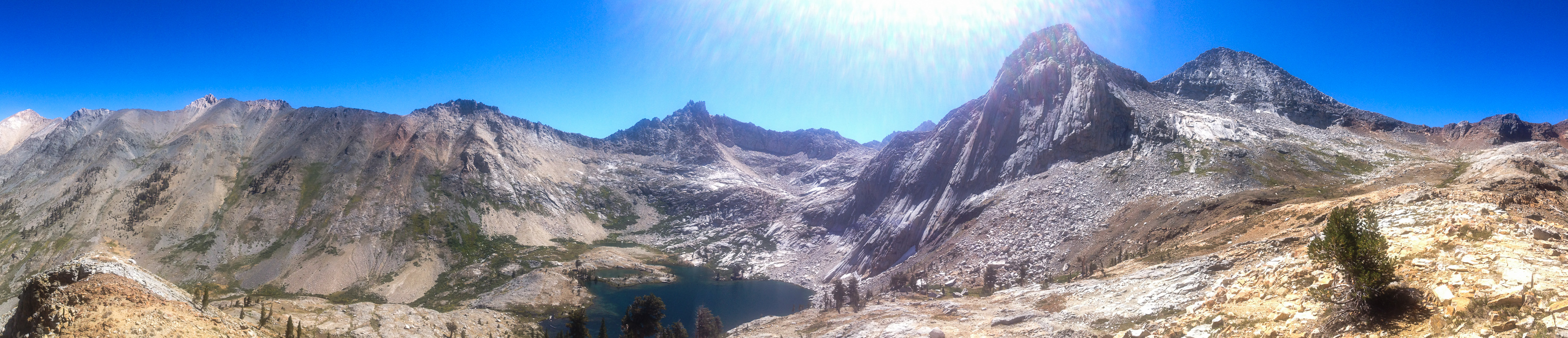
Here's an iPhone panorama of Eisen (far left) and Spring Lake:


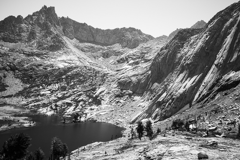
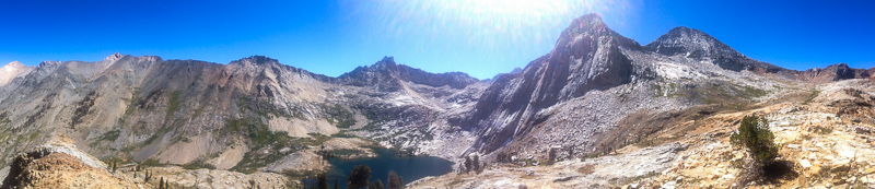
Spring Lake basin (click for bigger)

Murphy is kind enough to drive back down the beastly road while I sleep, and then we change spots for the long and boring trip home. Big push for 24 hours, but there are worse ways to spend a day!

-

Monday, February 3, 2014

The Fed, Revisited

Here's another look at my across-the-street architectural test subject, this time in considerably better light.


Thanks, sky!

I can sit at my desk, keep an eye on the light on the building and in the sky, and excuse myself for a few minutes when it's looking good. Pretty easy pickins, really.

-

Past Detritus